Introduction
Soils of Antarctica are widely regarded as poor regarding nutrients, places for plants and habitats for organisms. Some authors described them as young soils without horizons and raw in terms of their functions for soil processes [1]. King George Island has an ice-free area of about 8 %, weathered soils derived mainly from volcanic rock (andesite basalts and theirs pyroclastics), however, sedimentary rock may be also important in few sites. The periglacial condition with cryoturbation widely prevents active plant growth. Nevertheless, a great variety of soils has been described for Arctowski region, such as Haplorthels, Umbriturbels, Umbriorthels, Aquiturbels, Haploturbels, Sapristels, Mollorthels, and Psammorthels as determined according to Soil Survey Stuff 1998 [2]. Cryosols, Leptosols, Regosols and Fluvisols (WRB taxonomy) are described as main types for the Keller Peninsula region [3].
Ongoing climate warming affects Antarctic environments like others in the world. Several indicators show these effects which can be seen in ecological studies. For example the spread of the endemic higher plants to new places, so far only covered by lichens or mosses, leading to new environments with higher trophic relationships, followed by significant changes in the soil environment. Natural radioactivity is wide spread in the earth’s environment; it exists in biotic and abiotic components. Environmental natural gamma radiation is formed from natural radionuclides include the primordial radioactive elements in the earth's crust, their radioactive decay products, and radionuclides produced by cosmic-radiation interactions. Low levels of uranium, thorium, and their decay products are found everywhere; however, locations with higher concentrations of these radionuclides in their soil have higher dose levels. Natural radionuclides in soil generate a significant component of the background radiation exposure of the population [4].
Gamma radiation intensity in a region depends on soil and geographic structure. The natural radioactivity in soil comes mainly from the 238U, 232Th decay series and natural 40K, respectively [5].
Perú has been a State Party to the Antarctic Treaty since 1981, and has been accepted as a Consultative Party in 1989. In order to develop scientific studies in situ Perú established a Scientific Station, named Machu Picchu (ECAMP), located at King George Island in Admiralty Bay, which is used as a summer station [6]. The main objective of this study was to evaluate the annual absorbed dose from outdoor terrestrial radiation. This study would be useful for establishing base line data on the gamma background radiation levels in different areas of the ECAMP for assessment of radiation exposures to the environment and possible variations due to climate change.
Material and methods
The Machu Picchu Scientific Station (62°5´ S, 58°28´W) is a Peruvian polar scientific research facility in Antarctica (Fig. 1), established to conduct Antarctic research on environmental chemistry, physics, climatology and biology. The surface area of study is about 0.2 km2. Influence area cover 0.38 km distance from the Station (Table 1, Fig. 2). During January 2015, gamma dose rates were measured on the surface using a portable digital personal radiation detector RadEye PRD Thermo Scientific.
Results and discussion
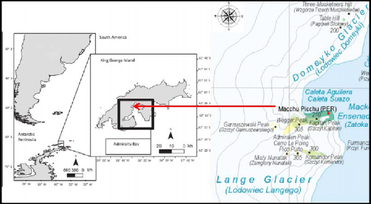
Figure 1. Admiralty Bay, King George Island –Makellar Inlet. Peruvian Antarctic Station “Machu Picchu”.
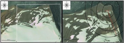
Figure 2. Surface area of study and influence area of the Peruvian Antarctic Station.
Outdoor gamma dose rates were determined in 140 sampling areas. Total outdoor gamma dose rates are presented in Table 1.
The Kolmogorov–Smirnov statistic quantifies a distance between the empirical distribution function of the sample and the cumulative distribution function of the reference distribution. The frequency Table and Kolmogorof-Smirnov Test show that the dose distribution is not homogeneous in the area (Fig. 3). Therefore the values of radioactivity in the area of estuary do not follow a normal distribution. The data has a value ranged between 31.5 and 71.1 nGy/h, it has a median value of 42.95 nGy/h and the median absolute deviation (MAD) for this data is 5.03 nGy/h with a variability of 14.58 %. Annual gamma dose was calculated as 376 44 Gy.
Table 1. Absorbed dose rates above soil in the Peruvian Antarctic Station (2014).
# | Latitude | Longitude | nGy/h | # | Latitude | Longitude | nGy/h | # | Latitude | Longitude | nGy/h | # | Latitude | Longitude | nGy/h |
1 | -62.0915 | -58.4711 | 46.0 | 36 | -62.0914 | -58.4706 | 39.9 | 71 | -62.0919 | -58.4684 | 39.3 | 106 | -62.0917 | -58.4691 | 40.6 |
2 | -62.0911 | -58.4713 | 48.6 | 37 | -62.0912 | -58.4695 | 43.3 | 72 | -62.0917 | -58.4687 | 37.2 | 107 | -62.0911 | -58.4689 | 42.9 |
3 | -62.0908 | -58.4714 | 44.3 | 38 | -62.0914 | -58.4692 | 48.3 | 73 | -62.0996 | -58.4616 | 33.9 | 108 | -62.0915 | -58.4688 | 41.6 |
4 | -62.0908 | -58.4720 | 44.3 | 39 | -62.0914 | -58.4691 | 46.0 | 74 | -62.0992 | -58.4617 | 38.2 | 109 | -62.0919 | -58.4684 | 41.9 |
5 | -62.0910 | -58.4720 | 43.6 | 40 | -62.0916 | -58.4698 | 42.6 | 75 | -62.0992 | -58.4617 | 38.2 | 110 | -62.0923 | -58.4680 | 41.9 |
6 | -62.0912 | -58.4717 | 40.9 | 41 | -62.0917 | -58.4691 | 42.3 | 76 | -62.0988 | -58.4618 | 35.2 | 111 | -62.0928 | -58.4676 | 40.3 |
7 | -62.0911 | -58.4723 | 50.3 | 42 | -62.0919 | -58.4690 | 42.9 | 77 | -62.0983 | -58.4622 | 36.6 | 112 | -62.0932 | -58.4674 | 47.0 |
8 | -62.0910 | -58.4731 | 48.0 | 43 | -62.0921 | -58.4688 | 45.3 | 78 | -62.0979 | -58.4626 | 37.9 | 113 | -62.0917 | -58.4896 | 47.6 |
9 | -62.0913 | -58.4734 | 44.6 | 44 | -62.0924 | -58.4686 | 47.0 | 79 | -62.0975 | -58.4632 | 34.2 | 114 | -62.0914 | -58.4735 | 49.3 |
10 | -62.0912 | -58.4740 | 35.9 | 45 | -62.0926 | -58.4683 | 44.3 | 80 | -62.0971 | -58.4637 | 35.2 | 115 | -62.0918 | -58.4887 | 47.0 |
11 | -62.0911 | -58.4736 | 37.9 | 46 | -62.0928 | -58.4680 | 42.9 | 81 | -62.0967 | -58.4642 | 38.2 | 116 | -62.0920 | -58.4873 | 44.0 |
12 | -62.0913 | -58.4739 | 47.0 | 47 | -62.0932 | -58.4677 | 43.3 | 82 | -62.0967 | -58.4642 | 38.2 | 117 | -62.0920 | -58.4854 | 44.6 |
13 | -62.0914 | -58.4744 | 44.6 | 48 | -62.0930 | -58.4687 | 47.0 | 83 | -62.0964 | -58.4648 | 33.9 | 118 | -62.0920 | -58.4829 | 46.3 |
14 | -62.0914 | -58.4754 | 37.9 | 49 | -62.0934 | -58.4679 | 51.0 | 84 | -62.0959 | -58.4652 | 36.6 | 119 | -62.0918 | -58.4787 | 49.3 |
15 | -62.0915 | -58.4769 | 35.9 | 50 | -62.0936 | -58.4678 | 49.3 | 85 | -62.0955 | -58.4656 | 44.0 | 120 | -62.0915 | -58.4754 | 42.3 |
16 | -62.0916 | -58.4778 | 40.3 | 51 | -62.0936 | -58.4684 | 56.0 | 86 | -62.0943 | -58.4667 | 48.0 | 121 | -62.0924 | -58.4793 | 47.3 |
17 | -62.0917 | -58.4787 | 34.9 | 52 | -62.0932 | -58.4675 | 42.9 | 87 | -62.0933 | -58.4680 | 48.6 | 122 | -62.0926 | -58.4806 | 39.3 |
18 | -62.0918 | -58.4792 | 36.9 | 53 | -62.0942 | -58.4670 | 47.3 | 88 | -62.0934 | -58.4679 | 53.3 | 123 | -62.0922 | -58.4815 | 39.3 |
19 | -62.0918 | -58.4797 | 37.6 | 54 | -62.0942 | -58.4681 | 45.0 | 89 | -62.0934 | -58.4679 | 50.3 | 124 | -62.0922 | -58.4764 | 47.0 |
20 | -62.0919 | -58.4806 | 35.9 | 55 | -62.0951 | -58.4662 | 52.3 | 90 | -62.0936 | -58.4678 | 50.3 | 125 | -62.0917 | -58.4748 | 44.6 |
21 | -62.0918 | -58.4786 | 36.6 | 56 | -62.0955 | -58.4656 | 37.6 | 91 | -62.0936 | -58.4684 | 47.3 | 126 | -62.0928 | -58.4727 | 44.0 |
22 | -62.0920 | -58.4790 | 37.9 | 57 | -62.0959 | -58.4653 | 36.9 | 92 | -62.0951 | -58.4702 | 41.9 | 127 | -62.0922 | -58.4718 | 49.3 |
23 | -62.0921 | -58.4795 | 33.9 | 58 | -62.0963 | -58.4646 | 37.2 | 93 | -62.0954 | -58.4702 | 42.9 | 128 | -62.0930 | -58.4677 | 53.3 |
24 | -62.0922 | -58.4805 | 31.5 | 59 | -62.0970 | -58.4640 | 34.9 | 94 | -62.0936 | -58.4695 | 55.0 | 129 | -62.0927 | -58.4682 | 48.3 |
25 | -62.0922 | -58.4812 | 35.2 | 60 | -62.0975 | -58.4633 | 32.2 | 95 | -62.0936 | -58.4695 | 55.0 | 130 | -62.0925 | -58.4683 | 56.7 |
26 | -62.0921 | -58.4774 | 40.9 | 61 | -62.0978 | -58.4628 | 37.9 | 96 | -62.0938 | -58.4705 | 42.3 | 131 | -62.0920 | -58.4688 | 55.0 |
27 | -62.0922 | -58.4761 | 45.6 | 62 | -62.0982 | -58.4622 | 38.2 | 97 | -62.0938 | -58.4723 | 50.0 | 132 | -62.0917 | -58.4690 | 42.3 |
28 | -62.0923 | -58.4764 | 41.3 | 63 | -62.0986 | -58.4618 | 34.6 | 98 | -62.0950 | -58.4738 | 49.3 | 133 | -62.0919 | -58.4696 | 48.0 |
29 | -62.0920 | -58.4757 | 48.6 | 64 | -62.0990 | -58.4617 | 37.2 | 99 | -62.0944 | -58.4745 | 47.6 | 134 | -62.0919 | -58.4697 | 71.1 |
30 | -62.0917 | -58.4748 | 40.6 | 65 | -62.0996 | -58.4616 | 38.6 | 100 | -62.0940 | -58.4745 | 36.2 | 135 | -62.0924 | -58.4695 | 49.7 |
31 | -62.0920 | -58.4745 | 37.6 | 66 | -62.0995 | -58.4614 | 33.9 | 101 | -62.0939 | -58.4734 | 49.7 | 136 | -62.0914 | -58.4701 | 51.0 |
32 | -62.0921 | -58.4739 | 35.9 | 67 | -62.0989 | -58.4617 | 35.6 | 102 | -62.0931 | -58.4688 | 51.7 | 137 | -62.0912 | -58.4709 | 49.3 |
33 | -62.0927 | -58.4735 | 35.6 | 68 | -62.0986 | -58.4617 | 38.9 | 103 | -62.0929 | -58.4678 | 45.6 | 138 | -62.0914 | -58.4715 | 52.0 |
34 | -62.0915 | -58.4736 | 38.6 | 69 | -62.0925 | -58.4679 | 37.2 | 104 | -62.0925 | -58.4682 | 49.0 | 139 | -62.0912 | -58.4724 | 48.6 |
35 | -62.0916 | -58.4724 | 39.9 | 70 | -62.0922 | -58.4681 | 38.6 | 105 | -62.0921 | -58.4687 | 46.0 | 140 | -62.0925 | -58.4683 | 45.6 |
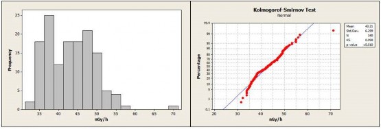
Figure 3. Frequency table and Kolmogorof-Smirnov test.
The contour map of the dose rate shows that the highest levels are found in the area of the scientific station site (Figure 4). The dose values are far below the doses reported in the Peruvian territory due to the geographical location of the statio, Benavente, Celedonio and Manosalva report on Peruvian territory, depending on the height above sea level, environmental effective dose values above 100 nSv/h [7, 8, 9, 10]. On the other hand, the average outdoor gamma dose rate in air of Turkey was 118 nGy/h [11].
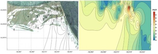
Figure 4. Distribution of absorbed dose in the study area.
Conclusions
A total of 140 measurements were made covering the area of the Peruvian Antarctic Station “Machu Picchu”. From the measurements made here, the average outdoor gamma dose rate in air due to terrestrial and cosmic radiations was found to be about 43 nGy/h and the median annual dose was found to be about 376 Gy.